India is a federal union comprising 28 states and 8 union territories. It is world’s largest democracy and second most populated country in the world after China.
The country’s coastline measures 7,517 kilometres in length, out of which 5,423 kilometres belong to peninsular India and 2,094 kilometres belong to Islands.
Broadly Indian is divided into six major zones: Northern India, Southern India, Eastern India, Western India, Northeast India and Central India.
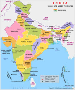
Northern Zone :
- The northern states of India are comprising Union Territories Chandigarh, Delhi, Jammu and Kashmir and Ladakh and states Haryana, Himanchal Pradesh, Punjab and Rajasthan.
Jammu and Kashmir is called the crown of India because the state is shaped like a crown and is located at the head of India. Haryana and Punjab share Chandigarh as a common state capital. This is because Haryana was a part of Punjab till 1966. - Delhi, the capital of India, is the largest metropolis in India.
Central Zone:
- Central India comprises the States of Chhattisgarh, Madhya Pradesh, Uttarakhand, Uttar Pradesh.
- Uttaranchal, was created from from northwest Uttar Pradesh in November 2000 with the enforcement of Uttar Pradesh Reorganisation Act, 2000, (renamed Uttarakhand in 2007),
- Chhattisgarh, was also created from eastern Madhya Pradesh in November, 2000 with the enforcement of Uttar Pradesh Reorganisation Act, 2000,
Eastern Zone:
- It includes the states of Bihar, Jharkhand, Odisha, West Bengal. Bengali is the dominant language in the state of West Bengal. In contrast Odia and Hindi are the principal language in the state of Odisha, Jharkhand and Bihar. English, Maithili and Urdu are the other languages spoken in the Eastern India.
- Orissa was renamed Odisha in 2011.
- Jharkhand was created from southern districts of Bihar in November, 2000, with the enforcement of Bihar Reorganisation Act, 2000.
Western Zone:
- Popular states of Western India are Gujarat, Goa and Maharashtra and Union Territory of Dadra and Nagar Haveli and Daman & Diu. In comparison to eastern India, western India have prosperous economy with a relatively high standard of living.
Northeast Zone:
- This zone of India comprises Assam, Arunachal Pradesh, Manipur, Meghalaya, Mizoram, Nagaland and Tripura; The State of Sikkim has also been included in the North Eastern Council vide North Eastern Council (Amendment) Act, 2002 notified on 23 December 2002.
Which book should I refer to for Ethics Integrity and Aptitude?
Southern Zone:
- It covers the states like Tamil Nadu, Kerala, Karnataka, Telangana with the Union Territories of Lakshadweep, Puducherry and Andaman & Nicobar Islands.
- Pondicherry was renamed Puducherry in 2007.
- Telangana was created on 2 June 2014 from ten former districts of north-western Andhra Pradesh.
- Indira Point, the southernmost point of India, lies in the Andaman and Nicobar Islands. However, it got submerged in water when the Tsunami hit India in December 2004.
- Within the Andaman and Nicobar Islands also lies Ritchie’s archipelago, a prominent archipelago of India. An archipelago refers to a group or cluster of islands.
- Like the Andaman and Nicobar Islands, Lakshadweep is also a famous archipelago. It is also called the Coral Paradise of India, because of the presence of some beautiful coral reefs.
Also Read More Article like this for UPSC Preparation on : EDEN IAS GS Articles
Source: @edenias, @nextgurukul, @popularanswers, @tetsuccesskey, @nextgurukul